Modbury, Part 2
This is reposted on Blogger January 2022 after being lost on Photoblog.
It was first posted on Photoblog
by Gethin Thomas AUGUST. 30, 2021
I pick up where I left off, outside The White Hart, walking up the "High Street" or Church Street, to give it it's proper name, to, surprise surprise, the church.
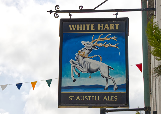
The White Hart and Assembly Rooms, are Grade 2 Listed and were given heritage protection back in 1967.
At noon, the market bell used to announce the start of the weekly market which sold produce from local farms. The market became the focal point of the area when, in 1774, a cattle and livestock market was established.
These markets took place on the second Monday of each month around the streets of Modbury. Sheep pens were set up outside the White Hart and pigs were sold outside the Exeter Inn.

Excellent town planning or happy accident has led to the two main pubs being opposite each other, both joined by a zebra crossing for easy passage between the two when a little inebriated, as you can see below. Inebriated is a lovely word and often a lovely feeling.
Inebriated- to make drunk. Affected by alcohol. Late 15c., from Latin inebriatus, past participle of inebriare "to make drunk.
If livestock markets were still being held in Modbury it would be a right mess, with sheep one side of the road, pigs the other and zebras in the middle, and the Amazon delivery driver negotiating all of them on his way from Plymouth to my house to deliver an urgent new trinket that I cannot live without.
A zebra crossing is a type of pedestrian crossing and a Belisha beacon is an amber-coloured globe lamp atop a tall black and white pole, marking said pedestrian crossings of roads in the United Kingdom. The beacons were named after Leslie Hore-Belisha, the Minister of Transport who, in 1934, added beacons to pedestrian crossings, marked by large metal studs in the road surface. These crossings were later painted in black and white stripes, thus are known as zebra crossings.
A zebra crossing gives the pedestrian right of way once their foot is on the crossing. The motorist must stop by law, and may not proceed until the pedestrian is clear of the crossing and has reached the pavement on the other side. Failing to stop at a zebra crossing while a pedestrian is still on the road could land you with a hefty fine (£100) and 3 penalty points on your licence. 12 penalty points will lose you your license, so if you have already hit three pedestrians be warned.
In the Road Traffic Act of 1930 all speed limits were controversially removed. By 1934 when Belisha became Minister of Transport, Britain had transformed into a hellscape of mayhem and it is no surprise that it was a record year for traffic deaths in the UK, with 7,343 deaths and nearly a quarter of a million injuries, half of which were pedestrians and three quarters in built up areas. By contrast, with twenty million more people today, the figure for deaths on the roads for 2019 was 1,870.
Interestingly, the figure for 2020 was 1,472 not much lower, considering 90% of people were off the roads for about 50% 0f the year during lockdown. In our village you could have happily laid down in the middle of the road for up to half an hour without any risk of the slightest bruise. So you do wonder how this figure was reached.
Hore-Belisha's Road Traffic Act 1934 introduced a speed limit of 30 mph for motor cars in built-up areas. Hore-Belisha rewrote the Highway Code and was responsible for the introduction of two innovations that led to a dramatic drop in the number of road accidents: the driving test and the Belisha beacon, named after him by the public. On his retirement, he was made vice-president of the Pedestrians' Association and, to this day, the logo of the organisation includes a Belisha Beacon. By my rough and ready calculation Belisha has so far saved over half a million British lives on our roads.
The latest iteration of Belisha Beacons features a flattened globe disc with a surround of LED lights as seen below. In this case the lamp posts double as beacon poles, being striped black and white on the lower half.

Any Americans reading this will surely have heard of the Stetson, but what you may not know is that Cornet Robert Stetson, was born in Modbury and baptised in St. George’s Church in 1615. We visit the church later.
He married Honour Tucker of nearby Plymouth and they emigrated to Massachusetts. A descendant, John B Stetson founded the hat company in 1865 after moving west. Stetson descendants still make generous donations toward the upkeep of the church where the Stetson family records reside. Stetson is an English surname with an unclear etymology, but possible stemming from "Stott" meaning a cattle rancher, or "Stytt," which means to hit (and was a likely nickname for fighters). Either way no respectable cowboy, whether a fighter or not would be seen without a Stetson on their head.


Below is what I would call holiday art or holiday home art. Made to look weathered and old but in impossibly bright sunny colours, to brighten up any home you visit for two weeks of the year. I quite like the lobster myself.
In part one I promised a cockerel, still to come, but at that point I hadn't noticed the cockerel in this window, so just in case you have been paying attention, this cockerel is not it. This cockerel is an interloper, as is the puffin, which is what I will be doing as the hill gets steeper.

I may have to make a firm commitment to feature a pasty shot in any future Devon post I make, it certainly wouldn't be difficult. I know that certain audience members would love it, as the word seems to have connotations across the pond.

The Exeter Inn is also, like the White Hart, grade 2 listed by Historic England and listed in 1967. Claiming to be 14th century there is an original inn license dating as far back as 1563.
A coaching inn, now public house. C16 or early C17. This is the oldest surviving Inn in Modbury and was a popular meeting place for the Royalist faction during the 17th century English Civil War. It was built in the 14th century with later additions in the 19th century. It has retained a unique decorative plaster ceiling on the first floor. A stream runs under the building.
On the 18th of November 1642 the first Battle of Modbury took place. The Modbury area was a Royalist stronghold in the English Civil War and the Sheriff of Devon, Sir Ralph Hopton and Sir Edmund Fortesque raised a force of men headquartered in Modbury at the Exeter Inn.
A large force of Parliamentarians under Colonel Ruthen with four troops of horse and 100 Dragoons were sent from Plymouth a Parliamentarian stronghold and met the Royalists at Modbury. Most of the Royalist soldiers dispersed leaving the officers besieged in the Court House and Champernowne House. The house was set on fire and all were transported to Plymouth.

The second Battle of Modbury took place a few months later in 1643 when the Royalist forces besieged Plymouth. Parliament sent a force to relieve Plymouth and their forces were 8000 strong and concentrated in Kingsbridge. An advance force were sent to Aveton Gifford where 2000 Royalists were guarding the bridge. The Royalists were driven back in battle, fighting field by field, all the way to Modbury, a distance of 4.4 miles, where, yet again they set up defensive positions in the Court House. The Royalists were severely beaten in a bloody battle and those who survived were forced to flee down a sunken lane leading south west from the church. This lane is still called Runaway Lane to this day.
Ultimately the Parliamentarians lost power and the monarchy was restored in 1660. In terms of the population of England at that time, the English Civil War was so protracted and bloody that more people died as a percentage, than died in World War I.

I referred to Champernowne House above and as you may guess this name is French in origin. The Chapernownes hail from Normandy and probably arrived soon after the Norman invasion of 1066. Judicious marriages and being on the right side of history as we say now, led to the family acquiring great wealth and large estates of land. By the reign of Henry VIII the Champernownes had gained much influence at court and Katherine Champernowne through her second marriage bore a son called Walter Raleigh, later Sir Walter Raleigh, favourite of Queen Elizabeth. The son from her first marriage, Sir Humphrey Gilbert founded the colony of Newfoundland.
Nobody ever came up with a catchy name for Newfoundland, like Virginia or Pennsylvania or even New York. Presumably Newfoundland didn't resemble anywhere the settlers recognised or it could have been New Somerset, or New Devon, so being completely unfamiliar to all who arrived it still remains just plain old New Found Land to this day. It's not even new anymore.
Raleigh's good fortune did not last; the Queen died on 24 March 1603. Raleigh was arrested on 19 July 1603 at what is now the Old Exeter Inn in Ashburton, charged with treason for his involvement in the Main Plot against Elizabeth's successor, James I, and imprisoned in the Tower of London. Raleigh was beheaded in the Old Palace Yard at the Palace of Westminster on 29 October 1618.
Raleigh's head was embalmed and presented to his wife.
Yes, you heard right, and no, it wasn't meant to frighten her to death, it was considered a nice gesture back then to present heads of executed prisoners back to their loved ones. They hadn't invented PTSD back then and people were pretty much unshockable given how much bloodshed and disease there was around. An embalmed head was considered almost ornamental and cuddly like cat figurines or teddies are today. It has been said that Lady Raleigh kept her husband's head in a velvet bag until her death.
Presumably she brought him out at parties as a conversation piece or on special occasions.
After her death 29 years later, what was left of the head was removed to his tomb and interred at St. Margaret's Church with the rest of him.

Below is a grade 2 listed water conduit, again listed in 1967. Somebody in Modbury was obviously very busy in 1967 getting stuff listed, probably a good time to do it before modern development got underway.
It is described officially as...
Street conduit with flanking walls and steps. 1708, part of the water supply system presented to the town by Nicholas Trist, the Lord of the Manor. Granite in squared blocks, supported by rubble walls, cast iron railings. About 2 metres wide overall, and up to 2.5 metres high, set to steep street.
Although the concept of bacteria was not understood, people had come to experience that water was a dangerous commodity. Open water was risky and this is why beer drinking was so widespread. People had long realised that brewed beer was safer to drink than water. Even children drank beer.
Small beer is a lager or ale that contains a lower amount of alcohol by volume than most others, usually between 0.5% and 2.8%. Sometimes unfiltered and porridge-like, it was a favoured drink in Medieval Europe and colonial North America compared with more expensive beer containing higher levels of alcohol. Small beer was also produced in households for consumption by children and by servants. In many places, especially towns and cities, it was safer to drink than the water available. Small beer is also an expression.
Small Beer - If you say that something is small beer, you mean that it is unimportant in comparison with something else.
For example one could say Prince Harry's new role as Private Jet Flying Climate Emergency Expert is Small Beer compared to his previous role as Prince of the Realm, sixth in line to the throne.
Street conduits were the earlier solution to providing clean water in towns piped directly from clean springs, and were almost always provided by benefactors, a precursor to water piped into individual properties. The area set back above the carving below would have been open with a tap of running water, since filled in.

A non-conformist chapel dated 1791.

As you climb the hill to the church all the angles get crazier and the houses are placed in steps one above the other, the front door of one property being almost on a level with the upper floor of the next.

Grandiose embellishments abound and the grander and larger properties flourish near the top of the hill where there is better light, air and weather.

Now called Triggs House, there are many cases of people called Triggs in parish records. One, James Triggs was a farmer of fifty acres, could this have been him?

A well executed paint job below demarks a colour difference between two neighbours. I particularly like the gilded numbers in Roman numerals on the glass window above the door on the left. Even these two front doors right next to each other are offset at ground level due to the hill.


I wanted to capture the full depth of these properties and their relationship below as the row at the front was called Sun Terrace (being at the top of the hill), while through the narrow gap at the back was Sun Cottage which appeared to have it's own sun terrace. It took a lot of shuffling of feet left and right to get the composition just right, because the Lamp Post was also part of the problem. I was quite pleased with the result.
Modbury used to be gas lit, which was quite unusual for a village of this size. It still maintains the traditional Lamp Posts with it's ladder rests for the gas lighter who would have come around every night to light the lamps. Today, like the new generation Belisha Beacons, they are LED.


If you have seen the movie The Madness of King George you will have seen portrayed, another famous individual from Modbury.
SIR GEORGE BAKER was born in Modbury in 1722. He was educated at Eton and King’s College, Cambridge, and was subsequently elected to a Fellowship of the College. He practised medicine in Lincolnshire for a few years before seeking broader opportunities in London in about 1761, contributing an academic elegance to the medical scene. He was ‘Physician-in-Ordinary’ to George III and was created a baronet in 1776. He was also a Fellow of the Royal Society and held the most important offices in the Royal College of Physicians, where he was President from 1785 to 1795. He attended the King in his second attack of madness (the first was hushed up) and administered to him for many years.
The current heir to the throne is said to converse with plants, but I'll leave that with you.

This is a notable and unusual building below. It had on the left what looked like a coach entrance now covered up with an added doorway so I suspected it was once an inn. It turns out I was right, as it was formerly The Rose and Crown pub.
Also grade 2 listed but as recently as 1990. The small plaque on the upper level between the two windows on the left is an insurance marker, for the Royal Exchange Insurance Company which features architectural detail with a crown.
The insurance markers were displayed at a time when there was no public fire service so that any private fire service, if attending the fire, would know that the property carried fire insurance and were fully paid up.
There are an additional seven pubs known until recent times in Modbury that no longer exist.


I have now reached the church and there is only enough room left in this post to show some exterior features. I will leave any interiors and most of the history for the next post.
St. George's church is grade 1 listed. There is reference to the building which dates back to 1084 although most of what is seen today dates mostly from the 13th century or later. There are still parts of the building that pre-date the Doomsday Book of 1086. It's architecture reflects the fact that a priory was built next to it in the 12th century.
In part 1 of my Modbury photo walk I mentioned the arrival of the French after the invasion of 1066. After they took over and moved in all their stuff, and made themselves comfortable, got their feet under the table, and threw up a few hundred castles to keep the locals in order, they decided to do a bit of a stock take, to see how profitable the invasion had actually been, a sort of cost analysis of being a terrible neighbour, so they put together a large list of stolen property that they called the Doomsday Book.
The Anglo-Saxon Chronicle states that in 1085 the French king sent his agents to survey every shire in England, to list his holdings and calculate the dues owed to him.
The assessors' reckoning of a man's holdings and their values, as recorded in Domesday Book, was dispositive and without appeal. The name "Domesday Book" came into use in the 12th century. Richard FitzNeal wrote in the Dialogus de Scaccario (c. 1179) that the book was so called because its decisions were unalterable, like those of the Last Judgement, and its sentence could not be quashed.
What follows is a series of doors and windows indicating the great age of the church.


In the next part of the walk I will show some interior shots of the church and investigate a narrow route back down the hill. Don't forget, as I promised in part one, there are still clocks, cockerels, thousands of soldiers and many camels still to come.

Another one of your beautiful posts..how you eye grabbed the various doors and buildings and captured it on camera. The perspectives taken in these photos are relly nice even the one where you merged two photos together. They came together perfectly showing us the slope of the street. Whoever is living in either one of those houses is probably pretty skinny..having to go up and down this street is the perfect exercise.
ReplyDelete